Take a Tour – History
A Rich and Fascinating History
The history of New Orleans under French, Spanish, and finally as part of the Louisiana Purchase, United States rule, is rich and fascinating. The environment and the city’s constant battle with water, the mix of cultures and the almost yearly yellow fever or plague epidemics, have all impacted to define these cemeteries. Historical maps and archival documentation of these many factors have played an important role in our efforts to map the cultural geographic context of the cemetery and the surrounding neighborhood.
Owned and managed by the Catholic Archdiocese of New Orleans, St. Louis Cemetery No. 1, built in 1789, is the oldest surviving urban cemetery in New Orleans, Louisiana, and is of national, as well as local, significance. Among the many reasons for its importance are the cemetery’s unique and early design, its reflection of New Orleans social diversity, and the high quality and integrity of its architecture and landscape. Follow the links on this page or click on the four colored buttons above to explore different levels of information on the history of St. Louis Cemetery No. 1.
St. Louis Cemetery No. 1 – Site History
Built in 1789, St. Louis Cemetery No. 1 is New Orleans’s oldest remaining cemetery. Before its construction, prominent inhabitants were entombed within the Parish church. In 1725, New Orleans’s first independent cemetery, St. Peter’s Street Cemetery, was opened outside of the city limits on the upriver west side of St. Peter Street, presently the area between Burgundy and Rampart Streets.
The history of St. Louis Cemetery No. 1 really began in 1788, a year of great trauma for the city of New Orleans, as the river overflowed, a great fire destroyed 856 buildings and 80% of the city, and a serious epidemic broke out amongst the populace.1 St. Peter’s Street Cemetery was full and the Cabildo was warned by local physicians that the proximity of the cemetery to the city could cause another serious epidemic. Following the Spanish royal decree, the city ordered a new Catholic cemetery to be established and St. Louis Cemetery No. 1 was built outside the city in an area just north of Rampart Street.2
The cemetery was not designed to be segregated by race, but by religion, as the Protestants were placed in a section in the rear. The site as it stands now is a microcosm of New Orleans history. The diversity of New Orleans can be seen within the site as the poor are buried next to rich and people of different races and ethnicities are buried next to each other.
The building of the Carondelet Canal in 1795 led to later construction of a navigational road that caused the front part of St Louis Cemetery No. 1 to be removed during the first half of the 19th century.3 This road later became the site of a railroad line around the turn of the 20th century. In 1822, the cemetery was once again shortened when part of the Protestant section was removed during an extension of Tremé Street. In order to lay the street, the city offered Christ Church a tract of land on Faubourg Street for the building of a new Protestant cemetery and the remains were removed to this spot.4 Only a portion of the original Protestant section remains today.
Meanwhile, in 1817 an epidemic resulted in the formation of a board of health. This office decided that the “exhalations of the dead at funeral services and the transporting of the dead through the streets spread disease.” This led to the passage of a city ordinance on March 22, 1821 forbidding the placing on view of the dead during any funeral service from the first day of July through December. Before this time, all funerals took place at St. Louis Cathedral and processed to St. Louis 1 from there. To rid the city of the danger that these funeral processions might present, a funeral chapel (currently Our Lady of Guadalupe Church) was built adjacent to the cemetery. At that time it was called the Mortuary Chapel of St. Anthony, and it was designed by the French architects Gurlie and Guillot. Today it stands as the oldest Church in the city and its view of St. Louis Cemetery No. 1 is obstructed by the four lanes of Basin Street.5
- Samuel Wilson Jr. and Leonard V. Huber, The St. Louis Cemeteries of New Orleans (New Orleans: St. Louis Cathedral, 1963), 7-8.
- Records and Deliberations of the Cabildo, Oct. 17 1788, typescript, WPA, 1936.
- Federal Writers’ Project, New Orleans City Guide (Boston: Houghton Mifflin, 1938), 400.
- Wilson, 12.
- The History of Our Lady of Guadalupe Church, http://www.saintjudeshrine.com/history.htm.
Necrogeography/The Geography of Death
If man is the only animal who buries his dead,1 then the cemetery, as the final repository, represents the largest material correlate related to the rituals of death, including commemoration. In its layout and design, monuments, tombs and gravemarkers, motifs and inscriptions, plantings and votives, the cemetery encompasses our personal and collective responses in confronting death, and in so doing, it reveals much about our attitudes toward life.
According to contemporary scholarship, death and dying have become significant topics as they relate to the legal, medical, and moral issues of living and dying in the twenty-first century. Extended life expectancy, assisted suicide, euthanasia, AIDS and abortion have forced Americans to confront mortality despite an elaborate avoidance of death. Most Americans today have distanced themselves from death; many have never seen a corpse or attended the death of a family member or friend, a situation unlikely a century earlier given the frequency of disease and epidemics, the close proximity of the family, and former prevailing attitudes of private and personal mourning. Instead of the home, most death now occurs in the hospital and hospice and subsequent rituals of wake and burial are arranged by third parties with minimal or passive input from the family and religious institutions.
This situation is by no means unique to North America and it has developed gradually during the social and economic changes that befell most industrialized nations beginning in the mid-nineteenth century. Recent scholarship has begun to critically examine these changes in beliefs and attitudes toward death, and the associated customs of the mourning, disposal, and commemoration in nineteenth and twentieth century Europe and North America. Both general and specific studies by historians, archaeologists, cultural anthropologists, and folklorists have long-focused on the design, typology, and stylistic development of gravestones, tombs, and entire burial grounds and cemeteries as material culture and cultural landscapes. What has generally been ignored, however, is the significant role secondary activities such as tourism and preservation have played in the ideological and physical transformation of these places over time beginning in the mid-nineteenth century.
To behold the American cemetery today is to challenge contemporary society’s amnesia and its obliviousness to traditional monumentality and history. To celebrate the cemetery is to embrace a postmodern predilection for the convergence of history and memory and to recognize individual subjective emotion as well as the universal human condition. In its myriad of individual tombs and markers, the cemetery evokes the human social community. Behind their walls, New Orleans’ early cemeteries still provide a place for contemplative reflection, removed from the intrusions of the city. In their narrow interconnected alleys, they confound like a maze taking visitors on an instructive journey past former lives. Through the successive chronological epitaphs of the deceased, they link past to present, each tomb standing as both text and artifact, offering a group portrait of New Orleans’ complex society through time. In its collective, contained, and detached landscape the cemetery presents a parallel urban world that truly exists on the other side of the looking glass.
Text adapted from remarks by Frank G. Matero featured in the April, 2002 exhibit “Dead Space: Defining the Creole Cemetery ” at the University of Pennsylvania, Graduate School of Fine Arts.
- Louis Vincent Thomas, Anthropologie de la Mort, Paris: Payot, 1975.
New Orleans – A City Develops In Spite of the River
By the mid-seventeenth century, the French had established themselves in North America by claiming and settling around the St. Lawrence River and the Great Lakes, in the region now known as Quebec. They recognized the strategic importance that control of the waterways provided and sought to secure the mouth of the great Mississippi River. On April 9, 1682, the land now known as Louisiana was claimed for France by Robert Cavalier de La Salle and was named Louisiane, for Louis XIV. By 1700, there were French soldiers in the region to protect the area from encroachment by the Spanish, who already had colonies in Florida and had laid claim to the gulf coast of the North American continent. In 1717, John Law, a Scot, was given the exclusive charter to sell real estate and develop Louisiana for the French. Settlers from France and Germany were lured to New Orleans expecting financial opportunities and a healthy climate. Instead, most found an early demise in the mosquito and snake infested bayous.
Most historical commentators remarked on the poor, yet perfect location of the city founded in 1718 as New Orleans by Jean Baptiste Lemoyne de Bienville, the then Governor-General of Louisiana. Its history and development have been inextricably linked to the Mississippi River, with its large delta of below sea level swamp and marshland. The city is sited on a great bend in the Mississippi River bounded to the north, west and south by the river and the east by a large lake, Lake Pontchartrain. It lies near the mouth of the river, and near enough to bayous that could be navigated, so that a sheltered, deep-water port could be established.1 The strip of land almost a mile wide along the river’s bend was the best and closest area that Bienville encountered while exploring northward from the mouth of the river It was on relatively high ground and was considered large enough for a development. Economically and geographically, this original crescent of land was the perfect site for shipping and control of the waterways, and the best location for building a new city. In spite of the lack of local building stone and other resources, and the almost yearly yellow fever epidemics and other plagues, “New Orleans grew rapidly and before the Civil War, was the wealthiest and third largest city in the United States.”2
The city’s geography and constant battle with water, the mix of French, Spanish and American cultures, the Creole society, the large influxes of immigrants, the almost yearly yellow fever or plague epidemics, the city’s pattern of growth, and, of course the architecture, have all impacted the development of the cemeteries. See the Timeline for more events in history and the Project Bibliography for many excellent references on the history of New Orleans, Louisiana.
- Donnald McNabb and Lee Madere, A History of New Orleans (New Orleans: Lee Madere, 1997), 3.
- Joseph A. Stein, “New Orleans,” Pencil Points v. 19 (1938 April): 197.
Faubourg Tremé
In New Orleans, the Faubourg Tremé lies north of the Vieux Carré within an area generally agreed to lie between Canal St., North Broad St., Saint Bernard St., and North Rampart St. and encapsulates the site currently occupied by St. Louis I (see Site History). The Faubourg Tremé is significant to the history of the United States as it is one of the oldest neighborhoods in the nation to continuously house “free people of color.” For this reason, it is said that “the culture of the Creoles and the free persons of color is rooted, to a large extent, in Tremé and the sixth ward, which were substantially developed in the late 19th century.”1
The area to become Faubourg Tremé was first developed in 1725, when Chevalier Charles de Morand, an employee of the Company of the Indies, established the city’s first brickyard in the area of Bayou Road above Claiborne.2 Soon afterwards, Morand purchased the brickyard and much of its surrounding land and developed a large plantation upon the grounds, while continuing to manufacture bricks. At this time his holdings included the area surrounded by what is currently North Rampart, Claiborne Ave., and Bayou Road. In 1756 Morand extended his holdings to include the area bounded by Governor Nicholls, St. Bernard, Galvez, and Rampart, and in 1774 his era came to a close when he sold his land to Pablo Moro and his wife Julie Prevot.3 By 1780, most of the area had been acquired by Claude Treme, the husband of Madame Moro’s granddaughter and the namesake of the area. This land was given further value when in 1794, the Baron de Carondelet, Spanish Governor of Louisiana, decided to create a canal, “half a league long” from Bayou St. John to the town.4
The Canal ended in a square basin, to allow boats to turn, at what is currently the intersection of St. Louis and Basin Streets (see map below). Basin Street was later created and then widened by the Navigation Company of New Orleans to accommodate better travel to Canal Street in the 1820s. Until the construction of the New Basin Canal, the Carondelet Canal served as the only means of transporting products produced on the north shore of the lake to the city. The terminus of the canal in Tremé was used as a landing depot for schooners carrying lumber, firewood, charcoal, and other commodities. Warehouses soon appeared along the canal’s borders in Tremé to store these goods.
The Canal gave the area some commercial viability and soon Claude Tremé began to subdivide his plantation for further development. In 1798, Christoval T. de Armas purchased a portion of the plantation below Bayou Road, and in 1799, Tremé began subdividing his remaining land. In 1810, the remainder of the Tremé plantation was sold to the Corporation of New Orleans for $40,000 and by 1816, the city was selling this land in smaller subdivided lots for a profit.5 These lots were sold to both white people and free people of color, most of whom were either the children of white men or individuals who fled the slave uprisings in the West Indies. The free men of color who resided in Tremé were often musicians, craftsmen, and artisans. It was at this point in the late eighteenth and early nineteenth centuries that this suburb began to establish itself as a unique neighborhood of mixed ethnicities.
- Office of Policy Planning, Sixth Ward / Tremé / Lafitte Profile (City of New Orleans: The Historic New Orleans Collection, December 1978).
- Samuel Wilson, Jr. The Vieux Carré New Orleans Its Plan, Its Growth, Its Architecture. Historic District Demonstration Study, Conducted by Bureau of Governmental Research New Orleans, Louisican for the City of New Orleans, 1968, 23.
- Office of Policy Planning, Sixth Ward / Tremé / Lafitte Profile (City of New Orleans: The Historic New Orleans Collection, December 1978).
- 4.Robert J. Cangelosi, Which Way Tremé? An Architectural Terminal Project (Baton Rouge: LSU Department of Architecture, 1975).
- Office of Policy Planning, Sixth Ward / Tremé / Lafitte Profile (City of New Orleans: The Historic New Orleans Collection, December 1978).
Vieux Carré
Some might say that the city of New Orleans, specifically the French Quarter or Vieux Carré, is, and always has been, the quintessential cultural tourism city. Whether in New Orleans for leisure or business, the modern day visitor experiences an “otherness” that has changed, but has not been lost through the centuries.
New Orleans was originally settled in the area now known as the French Quarter, or Vieux Carré. After the Louisiana purchase, when the new “American’ immigrants began settling in New Orleans, they avoided the French Quarter, settling instead to the west of the Quarter in Faubourg St. Mary or what became known as the American sector. The Vieux Carré continued to be the home for the established Creole culture.
Christine M. Boyer describes the Vieux Carré situation during the 1870s, “By the 1870s it had become a melancholic symbol of ruin and decline for both the antebellum south and the Creole culture. An Illustrated Visitors’ Guide in 1879 shows images of the French Quarter withdrawing into the mouldy corners of a romantic ruin.” She posits that this nostalgic mood actually was the beginning of a self conscious construction of Creole New Orleans.1
A nationwide audience had access to the primarily fictional accounts of New Orleans architecture and Creole culture by George Washington Cable appearing in The Century Magazine and Scribner’s Magazine. “He popularized the aura of local color hanging over New Orleans’ architectural atmosphere and had diffused the sharpness of its imagery in picturesque ruinous forms.”2 Cable’s fabrications included architectural sites like the Old Absinthe House of 1790 and Madame Laturie’s Haunted House, both of which have since been created to meet the expectations of visiting tourists.
Today, these fabrications have become part of the district’s history, and the Vieux Carré has become the tourism jewel to a city that now depends on tourism. In 1895, Grace King called St. Louis Cemetery No. 1 “the mother cemetery, the Vieux Carré of the dead; as confused and closely packed a quarter as the living metropolis.”3
- Christine M. Boyer, The City of Collective Memory: Its Historical Imagery and Architectural Entertainments (Cambridge: The MIT Press, 1996), p. 325..
- Ibid. 325
- King, Grace. New Orleans: The Place and The People, (New York: Macmillan and Co.) 1895, 401.
All Saints’ Day
All Saints’ Day occurs each year on November 1st. Traditionally this was a major family event culminating weeks of tomb cleaning and maintenance activity. Flowers, mostly chrysanthemums, by the cartloads would come into the cemetery and the tombs would be decorated with vases of flowers and immortelles, or wreaths of flowers, beads or hair. During the day the cemeteries would be packed with people visiting the tombs and recalling past memories. Priests were on hand during the day and orphans, accompanied by nuns, would sit at the gate to collect donations.
In Louisiana, the celebration of death does not end with the funeral.1
The festival of the dead might be called the festival of the history of the city. Year after year from under their decorations of evergreens and immortelles, roses and chrysanthemums, the tombstones recall to the All-Saints pilgrims the names and dates of the past; identifying the events with the sure precision of geological strata.2
Historically, this yearly maintenance and attention kept the tombs well sealed and protected the interior structure from the aggressive New Orleans environment.
“It is the day in New Orleans when all the faithful go to the cemeteries to care for the graves of their loved ones. They whitewash the plaster walls of the vaults, clean the names cut into the marble slabs. And finally, they deck the tombs with flowers.”3
By the end of the nineteenth century, St. Louis Cemetery No. 1 was overcrowded and had fallen out of favor as New Orleans residents elected the more fashionable cemeteries of Lafayette and Metairie. As interment activity fell, so did visitation and family maintenance activities, leading to much of the deterioration seen in the cemetery today. However, new interest in the cemetery as an historic site has spurred volunteers to take up some of the traditional limewashing chores and families still celebrate All Saints’ Day at St. Louis Cemetery No. 1.
Funerary Plant Elements

- Leon Ronquillo, Matters of Life and Death, New Orleans, 1979.
- King, Grace. New Orleans: The Place and The People, New York: Macmillan and Co., 1895, 400-401.
- Vampire character Louis describes All Saints’ Day in the Anne Rice novel, Interview with the Vampire, New York : Knopf, 1976, 183.
Tomb Architecture
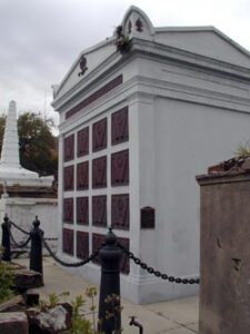
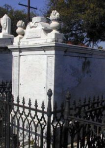
The accounts of Ingraham (1835), Didimus (1845), Lady Emmeline Stuart Wortley (1848-50) and Fredrika Bremer (1855), describe the beauty of the above ground tombs of St. Louis Cemetery No. 1 and 2. It is during this time that the well-read traveler was aware of cemetery advances in Paris at Père Lachaise, established in 1804, and the rural cemeteries such as Mt. Auburn (1831) in Massachusetts or Greenwood (1835) in Brooklyn, NY. It is also by the mid 1830s that the marble clad tombs designed by French émigré Jacques Nicolas Bussiere dePouilly were commissioned by prominent families for tombs in St. Louis Cemeteries No. 1 and 2 turning them into more monumental parks.
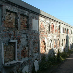
In the mid 1870s, George François Mugnier photographed St. Louis Cemetery No. 1, leaving us many images of the still active cemetery. The Society tombs that now dominate the view of the western section had already been built. Most family tombs seen in the Mugnier views are pediment tombs, or large platform and parapet tombs with multiple vaults, as many of the early single vault platform tombs had been “made-over” to accommodate multiple vault family burials. These “addition” tombs can be identified by changes in brick coursing or stucco, or tell-tale construction lines and odd placement of original tablets.
Key Tombs
Since the late 1800s, guide books have been listing tombs of famous people in St. Louis Cemetery No. 1. However, in addition to the tales of fame, money won and lost, wars and legal battles fought, and important civic achieve ments, there are many tombs that are important for their unique design,architecture or ornamentation. Several of the most significant include:


Map Illustrating Tomb Types
St. Louis Cemetery No. 1 contains several major types of tombs. Click on the legend blocks below to see definitions and examples of each type.

Cemetery Architects & Artisans
The Builders
The Builders
“Researchers face a delimma in gathering historical data on the numerious brick masons, stonecutters, sculptors, and architects who worked in the early cemeteries.”1
The field survey noted the few visual markings of architect, builder, mason, sculptor or metalwork designer/builder names. Additional archival and literature research yielded names of key builders known to be working in the St. Louis Cemeteries in the nineteenth century, however, most tombs in the site could not be exactly identified as to the craftspeople involved.
During the SAT project, local masons, plasterers, sculptors and metal workers were used to repair historic materials and to restore and replicate missing elements. The masons, Royal and Perrault, both come from families long involved in the above ground tombs of New Orleans, with Perrault being a direct descendant of the historic builder, Perrault, and the family tomb (#355) was one of the pilot tombs. The marble sculptor, Henderson, and the metal artisans recreated missing decorative elements. Care was taken to ensure that no mistaken historic identity was created. Using methods and design input of the past, they re-created new pieces of art.
- Peggy McDowell, “Influences on 19th-century Funerary Architecture,” New Orleans Architecture: Vol. III The Cemeteries, M. Christovich ed. Gretna, LA: Pelican, 1997.
During the SAT project, local masons, plasterers, sculptors and metal workers were used to repair historic materials and to restore and replicate missing elements.
Tomb Additions
As families grew larger, and as the almost yearly outbreaks of yellow fever caused many deaths, the family tomb was often not large enough, or available. Space could be rented in the surrounding wall vaults until a family vault was free. However, there is also abundant physical evidence that families expanded their tombs over time. As need for space grew, more vaults could be added and the tomb could expand upward, and sometimes outward, on the same plot.
Additions were defined in the survey as “clear evidence of construction changes and major modifications made to the tomb/marker, intentionally changing or expanding the form or orientation.” These additions tend to be historical, such as in the case of a step tomb changed into a pediment tomb, or the children’s addition to a large society tomb. The evidence of these additions is based on visible irregularities of form or construction. Many tombs with added vaults have cracks in their stucco that coincide with the top of the original structure. These added vaults may also show evidence of different color campaigns or different weathering patterns from the original vaults. Evidence includes: irregular tier rhythm, mismatched brick, unusual mortar joints, different colored stuccos, mismatched closure tablets, variations on tomb typology. Evidence may also be reinforced by typology of adjacent tombs.
3D drawings have been made to study how many tombs have changed in type over time due to additions. More work continues on basic construction and masonry techniques.
Drawings by J. Hinchman, 2002